News release
Arizona Eagle Mining Corp. Announces Completion of High Resolution TEM Geophysical Survey at the Eagle Project and Provides Update on McCabe Mine Reopening Studies
Discuss on
 $AZEM.V
Loading live prices…
Toronto, Ontario--(Newsfile Corp. - November 12, 2026) - Arizona Eagle Mining Corp. (TSXV: AZEM) (OTCQB: AZEMF) (the "Company" or "Arizona Eagle") is pleased to announce the completion of a 708 line-kilometre airborne time-domain electromagnetic ("TEM") geophysical survey at its Eagle Project (the "Property") in the historic McCabe gold-silver district of Arizona.
The survey was conducted by SkyTEM using a specially engineered system, referred to as the SkyTEM "Diamond", designed to provide exceptional near-surface resolution down to depths of 150 metres, making it ideal for delineating discrete structural features and identifying geophysical responses that may be associated with mineralization beneath shallow cover. Survey lines were spaced 25 metres apart and oriented at an azimuth of 145 degrees, perpendicular to the structural trend of the McCabe system and numerous parallel structures.
The survey was designed to evaluate the McCabe system and parallel structures identified through previous geological mapping, sampling and geophysical surveys, including structures that have not been historically drill-tested. Interpretation will integrate the new TEM data with existing geophysical surveys, geological mapping and geochemical data to refine the Company's understanding of these trends and prioritize targets for follow-up exploration.
Kevin Reid, Chief Executive Officer of Arizona Eagle, commented:
"The successful completion of this survey marks an important step toward obtaining a key dataset in helping us evaluate the broader structural setting of the Eagle Project. The 25-metre line spacing and specially engineered SkyTEM system were selected to resolve in greater detail the structures associated with historic gold and silver producers across the Property. We look forward to integrating these data with our previous geophysical, geological and geochemical work to refine targets along the McCabe system and evaluate parallel structures that have not been historically drill-tested. In addition to helping define extensions of the McCabe mine along strike, the recently completed SkyTEM survey has the potential to delineate new targets for the upcoming Phase 1 underground drill program."
TEM Geophysical Survey
SkyTEM completed 708 line-kilometres of airborne TEM surveying at 25-metre line spacing, with survey lines oriented at 145 degrees. This orientation crosses the NE-striking McCabe structural trend and the parallel structures, while the closely spaced lines provide highly detailed coverage for evaluating geophysical responses along and between the targeted trends. The combination of the specially engineered SkyTEM system and close line spacing was designed to provide very high resolution data for assessing the primary McCabe structure and 11 previously identified parallel structural trends hosting historic gold and silver producers. The survey is intended to better define these structures, evaluate their potential extensions beyond historically drilled areas and known surface mineralization, and identify additional exploration targets across the survey area.
Interpretation will combine the TEM dataset with results from previous helicopter-borne VTEM, magnetics and radiometrics and ground-based induced polarization surveys, together with geological mapping, surface sampling and other geochemical data. This integrated assessment is intended to refine and enhance our structural interpretations and identify priority targets for follow-up exploration. The Company intends to announce any material findings following completion of data processing and review of the survey interpretation, both of which are expected to be completed in approximately six weeks.
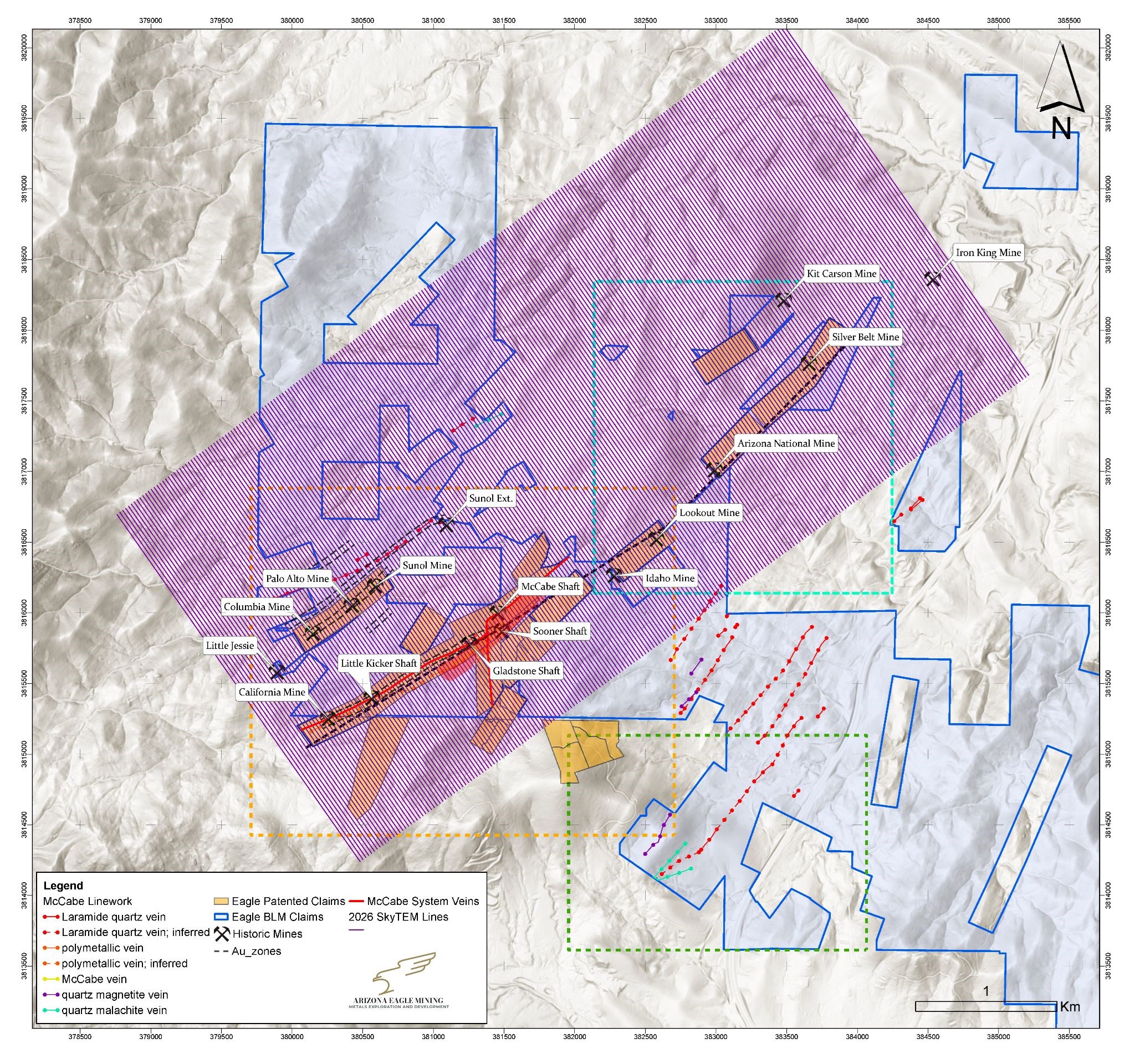
Figure 1. Plan view map showing the approximate SkyTEM survey coverage with historical mines, land tenure, and the historic McCabe Resource1 outline.
To view an enhanced version of this graphic, please visit:
https://images.newsfilecorp.com/files/10145/323556_b7b0b4de94338955_002full.jpg
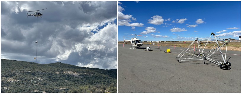
Figure 2. Left: Helicopter carrying SkyTEM "Diamond" system over survey area. Right: SkyTEM Diamond staging at Prescott airport.
To view an enhanced version of this graphic, please visit:
https://images.newsfilecorp.com/files/10145/323556_2.jpg
Update on McCabe Mine Reopening Studies
As announced on Sept 29, 2026, Arizona Eagle plans to open the prior sealed mine shaft and vent raise in order to drill test the 1984 Historic Resource1 from underground.
Once access is available, the Company expects to be able to reduce the metres drilled by up to 95%, as compared to drilling the same targets from surface. The cost per metre drilled is also budgeted to be significantly lower by drilling from underground.
Engineering studies for the reopening have commenced, with cement core sampling of the Sooner shaft and vent raise recently completed. Compression testing of the cores to evaluate safety and structural capacity are currently underway. Permitting, safety, and mine dewatering and water management studies are currently underway. A Phase 1 underground drill program is targeted for the third quarter of 2027.
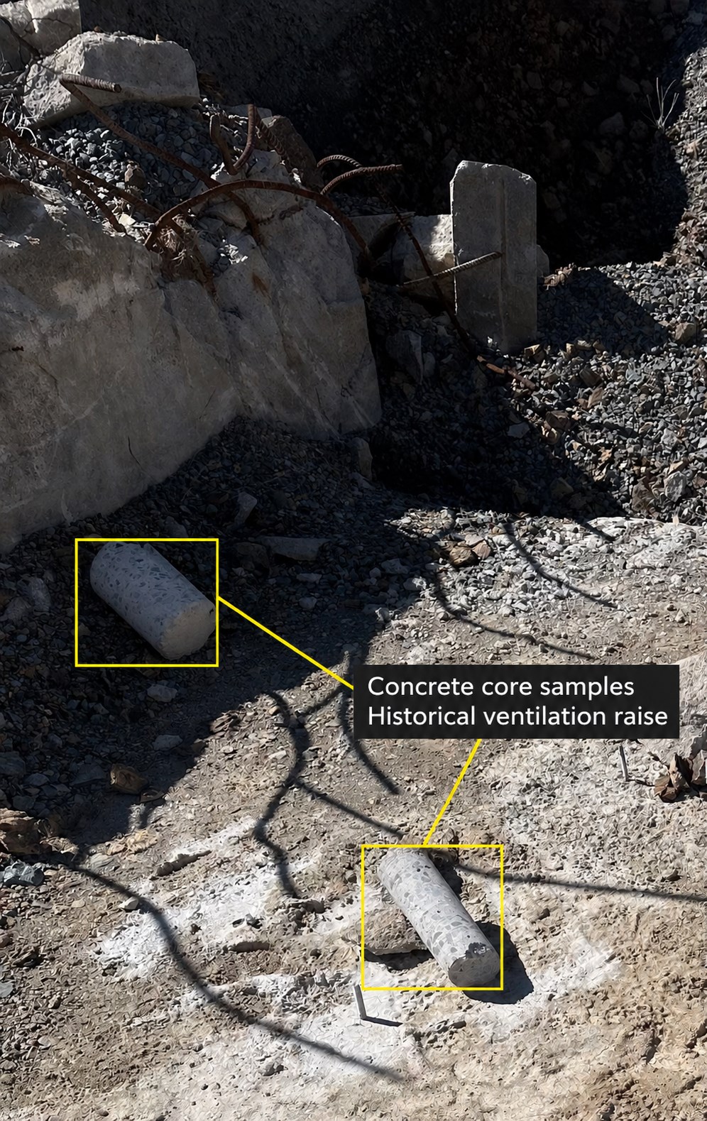
Figure 3. Photograph of concrete cores pulled from the historical ventilation raise at the McCabe mine. The concrete cores will undergo compression testing to evaluate safety and structural capacity.
To view an enhanced version of this graphic, please visit:
https://images.newsfilecorp.com/files/10145/323556_b7b0b4de94338955_005full.jpg
Eagle Project Overview
Arizona Eagle holds a 100% interest in the Eagle Project located in Yavapai County, Arizona. The Eagle Project is anchored by the past-producing gold and silver McCabe Mine, situated on 348 acres of private land. Stan West Mining historically invested more than US$35 million (approximately C$110 million in today's dollars) to drill and develop the mine. In 1984, Stan West Mining published a historic estimate of approximately 880,000 ounces of gold grading 11.7 g/t and 5 million ounces of silver grading 69 g/t (the "Historic Resource")1, defined to a maximum depth of approximately 440 metres and open in all directions.
Over the past two years, Arizona Eagle has expanded its total land position to 4,169 acres through staking and acquisitions surrounding the McCabe Mine. During this time, the Company completed exploration programs focused on geological mapping, surface sampling, helicopter-borne VTEM surveys and ground-based induced polarization surveys that identified multiple parallel mineralized structures not historically drill-tested. The Company also completed a maiden 3,400 metre drill program which returned 4.2 metres grading 5.73 g/t gold, with a higher-grade interval of 0.8 metres grading 11.35 g/t gold extending mineralization to the northeast of the McCabe Mine outside the Historic Resource1. Further step out drilling to the northeast encountered VMS type mineralization with a highlight of 11.8 metres grading 1.7% zinc, 9.17 g/t silver, and 0.17 g/t gold, including 2.2 metres grading 6.9% zinc, 36.30 g/t silver, 0.66 g/t gold and 0.97% lead.
Cautionary Note Regarding the Historical Estimate
The Historical Estimate is a historical estimate for the purposes of National Instrument 43-101 - Standards of Disclosure for Mineral Projects ("NI 43-101"). Its source is Knight, D.C., 1984, Stan West Mining Corp. McCabe-Iron King Belt project summary and financial information for shareholders, reporting a 1983 calculation by Derry, Michener, Booth & Wahl; there is no technical report on the Historical Estimate. Using the original terminology, it reported "Total Reserves" of 2,593,682 tons grading 0.34 ounces per ton ("opt") (11.7 g/t) gold and 2.0 opt (69 g/t) silver, containing 877,617 ounces of gold and 5,119,169 ounces of silver, in categories described as "Proven", "Probable - Drifting", "Probable - Drilling", "Possible" and "Geologically Inferred", the last of which accounted for approximately 700,000 of the contained gold ounces. It was prepared at an assumed gold price of US$360 per ounce and covered approximately 750 to 800 metres of strike to a maximum depth of approximately 440 metres; other key assumptions, parameters and methods, including cut-off grades, are not known to the Company. The historical categories are not the mineral resource and mineral reserve categories set out in NI 43-101 and the CIM Definition Standards on Mineral Resources and Mineral Reserves (the "CIM Definition Standards"). "Geologically Inferred" is most closely comparable to an Inferred Mineral Resource and "Possible" to an Indicated to Inferred level of confidence, while the "Proven" and "Probable" categories, which are not supported by any pre-feasibility or feasibility study, are more comparable to Measured and Indicated Mineral Resources than to mineral reserves under the CIM Definition Standards. The categories were also aggregated into a single "Total Reserves" figure, which would not be permitted for a current estimate.
The Company considers the Historical Estimate relevant because it covers the McCabe deposit, the principal past-producing mine on the Eagle Project, and reflects a substantial body of historical drilling and underground development. Because the Historical Estimate predates NI 43-101 and the CIM Definition Standards, is not supported by a technical report and has not been verified by a Qualified Person, the Company regards it as an indication of the historical work completed at McCabe rather than as a measure of the quantity or grade of mineralization, and it should not be relied upon. Historical production at the McCabe Mine was at grades materially below those reported in the Historical Estimate. The Company is also aware of more recent historical estimates prepared for the McCabe deposit in 1989 and 1993, each of which was limited to material near the then-existing underground workings, was substantially smaller in scope than the Historical Estimate, and is likewise not compliant with the CIM Definition Standards or NI 43-101. Verifying or upgrading the Historical Estimate as current mineral resources or current mineral reserves would require significant work including but not limited to compilation and validation of the historical drilling, sampling and assay data, additional drilling, re-sampling and re-assaying under modern quality assurance and quality control protocols, geological and grade modelling and the establishment of cut-off grades and other economic parameters, with no certainty of success. A Qualified Person has not done sufficient work to classify the Historical Estimate or those more recent estimates as current mineral resources or current mineral reserves, the Company is not treating any of them as current mineral resources or current mineral reserves, the Historical Estimate is not being and may not be used in any economic analysis, and investors are cautioned not to rely on it.
About Arizona Eagle Mining Corp.
Arizona Eagle is a mineral exploration company focused on the acquisition, exploration and development of mineral properties. Arizona Eagle's principal asset is the Eagle Project, a 4,169-acre property comprised of patented and unpatented claims located near the town of Prescott Valley in Yavapai County, Arizona. The Eagle Project is centered on the past-producing McCabe Mine, a high-grade gold-silver deposit, and includes multiple parallel structures hosting past-producing mines that remain largely untested by modern drilling. While Arizona Eagle's primary focus will be on the exploration and development of the Eagle Project, it will continue to own Core Nickel's land portfolio in the Thompson Nickel Belt of northern Manitoba.
The scientific and technical information contained in this news release has been reviewed and approved by Ben Somps, CPG, Vice-President, Exploration of the Company, who is a Qualified Person as defined under National Instrument 43-101 - Standards of Disclosure for Mineral Projects. Mr. Somps directly oversaw and supervised the geophysical survey in the field.
For Further Information
For further information on Arizona Eagle, please contact:
Kevin Reid, Chief Executive Officer and Director
Email: kreid@arizonaeaglemining.com
https://www.arizonaeaglemining.com/
Cautionary Statement Regarding Forward-Looking Statements
This news release contains forward-looking statements and forward-looking information (collectively, "forward-looking statements") within the meaning of applicable securities laws. Any statements that are contained in this news release that are not statements of historical fact may be deemed to be forward-looking statements. Forward-looking statements are often identified by terms such as "may", "should", "anticipate", "will", "estimates", "believes", "intends", "expects" and similar expressions which are intended to identify forward-looking statements. More particularly and without limitation, this news release contains forward-looking statements, including statements concerning the Company's exploration activities and the Phase 1 Drill Program at the Eagle Project, the expected timing and receipt of assay results, the mobilization of additional drill rigs, the potential expansion of the Historic Resource, and the pending acquisition to consolidate the Eagle Silver Project. Forward-looking statements are inherently uncertain, and actual performance may be affected by a number of material factors, assumptions and expectations, many of which are beyond the control of the Company, including expectations and assumptions concerning the Company's ability to complete the Eagle Silver Project acquisition on the proposed terms or at all (including the completion of satisfactory due diligence, the timely receipt of all required regulatory approvals, including the approval of the TSXV, and the Company's ability to obtain clear title to the underlying mineral claims), the Company's ability to execute on the Phase 1 Drill Program at the Eagle Project, commodity price fluctuations, the availability of financing on acceptable terms, environmental and permitting risks, and risks inherent in mineral exploration and development. Readers are cautioned that assumptions used in the preparation of any forward-looking statements may prove to be incorrect. Events or circumstances may cause actual results to differ materially from those predicted as a result of numerous known and unknown risks, uncertainties and other factors, many of which are beyond the control of the Company. Readers are further cautioned not to place undue reliance on any forward-looking statements, as such information, although considered reasonable by management of the Company at the time of preparation, may prove to be incorrect and actual results may differ materially from those anticipated. The forward-looking statements contained in this news release are made as of the date of this news release and are expressly qualified by the foregoing cautionary statement. Except as expressly required by securities law, the Company does not undertake any obligation to update publicly or to revise any of the included forward-looking statements, whether as a result of new information, future events or otherwise.
Neither the TSX Venture Exchange nor its Regulation Services Provider (as that term is defined in the policies of the TSX Venture Exchange) accepts responsibility for the adequacy or accuracy of this news release. No stock exchange, securities commission or other regulatory authority has approved or disapproved the information contained herein.
1 The Historic Resource is a historical estimate for the McCabe Deposit and is not current and should not be relied upon. The Historic Resource is unclassified and predates, and is not compliant with, current NI 43-101 standards; it is based on a 1984 "Total Reserve Estimate" by Stan West Mining. The Company's Qualified Person has not done significant work to classify the historic estimate as current mineral resources or current mineral reserves. Significant data compilation, re-drilling, re-sampling and data verification may be required by a Qualified Person before the historic resource can be verified and upgraded to be compliant with current NI 43-101 standards.
To view the source version of this press release, please visit https://www.newsfilecorp.com/release/323556