News release
Mithril Extends High-Grade Mineralisation To 700 Metres At Copalquin-Zaragoza Structure At Target 4
Discuss on
 $MSG.V
Loading live prices…
(TheNewswire)
 | |||||||||
Melbourne, Australia and Vancouver, Canada – TheNewswire – October 30, 2026 - Mithril Silver and Gold Limited ("Mithril” or the "Company") (TSXV: MSG) (ASX: MTH) (OTCQB: MTIRF) is pleased to report new drilling and surface sampling results from Target 4 at Mithril’s district scale Copalquin property, Durango State, Mexico.
Drilling has extended high-grade silver-gold mineralisation along the Copalquin-Zaragoza structure to 700 m of strike length, while new mapping and channel sampling around the historical San Manuel mine, located approximately 400 m along trend to the southeast, has returned gold grades of up to 16.55 g/t gold and 616 g/t silver over 0.6m. Together, these results further support Target 4 as a potential next resource growth area for the Company, complementing the Target 1 Mineral Resource Estimate (“MRE”) of 464 koz AuEq Indicated and 151 koz AuEq Inferred (See Table 3), currently undergoing a Scoping Study/PEA.
Target 4 Drilling Highlights
-
Drillhole intercept highlights include:
-
1.15 m @ 1,048 g/t AgEq1 (2.76 g/t gold and 855 g/t silver) from 104.75 m (CO26-006),
-
2.65 m @ 411 g/t AgEq (1.50 g/t gold and 305.6 g/t silver) from 109.8 m (CO26-006), including
-
0.90 m @ 622 g/t AgEq (2.85 g/t gold and 422 g/t silver) from 109.80 m, and
-
-
0.50 m @ 1,738 g/t AgEq (3.11 g/t gold and 1,520 g/t silver) from 154.50 m (CO26-009),
-
-
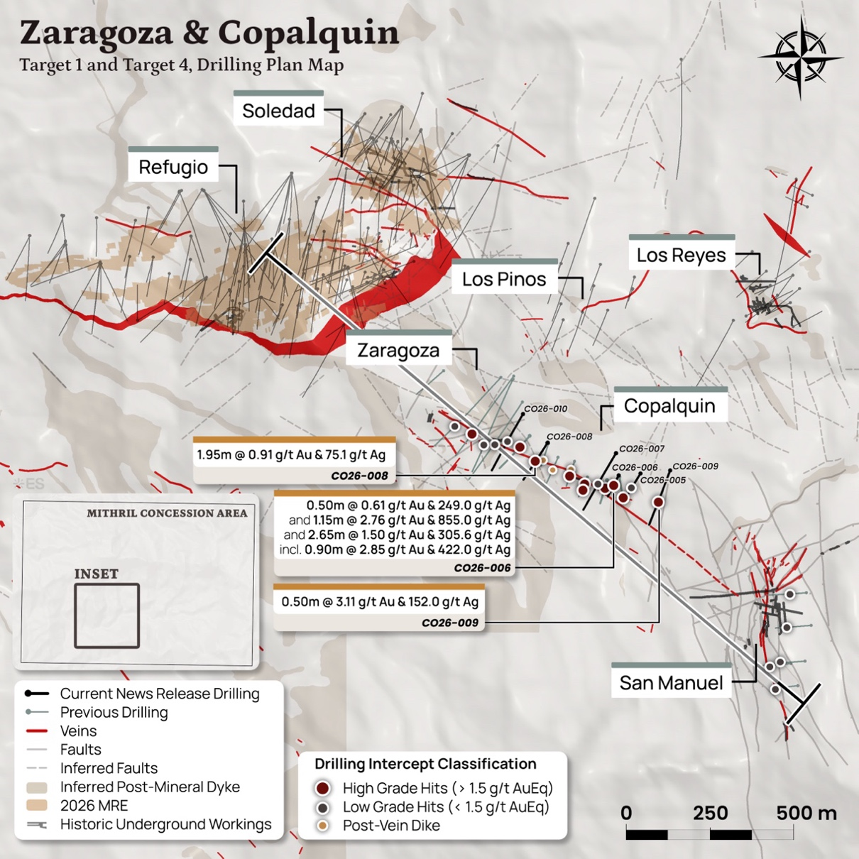
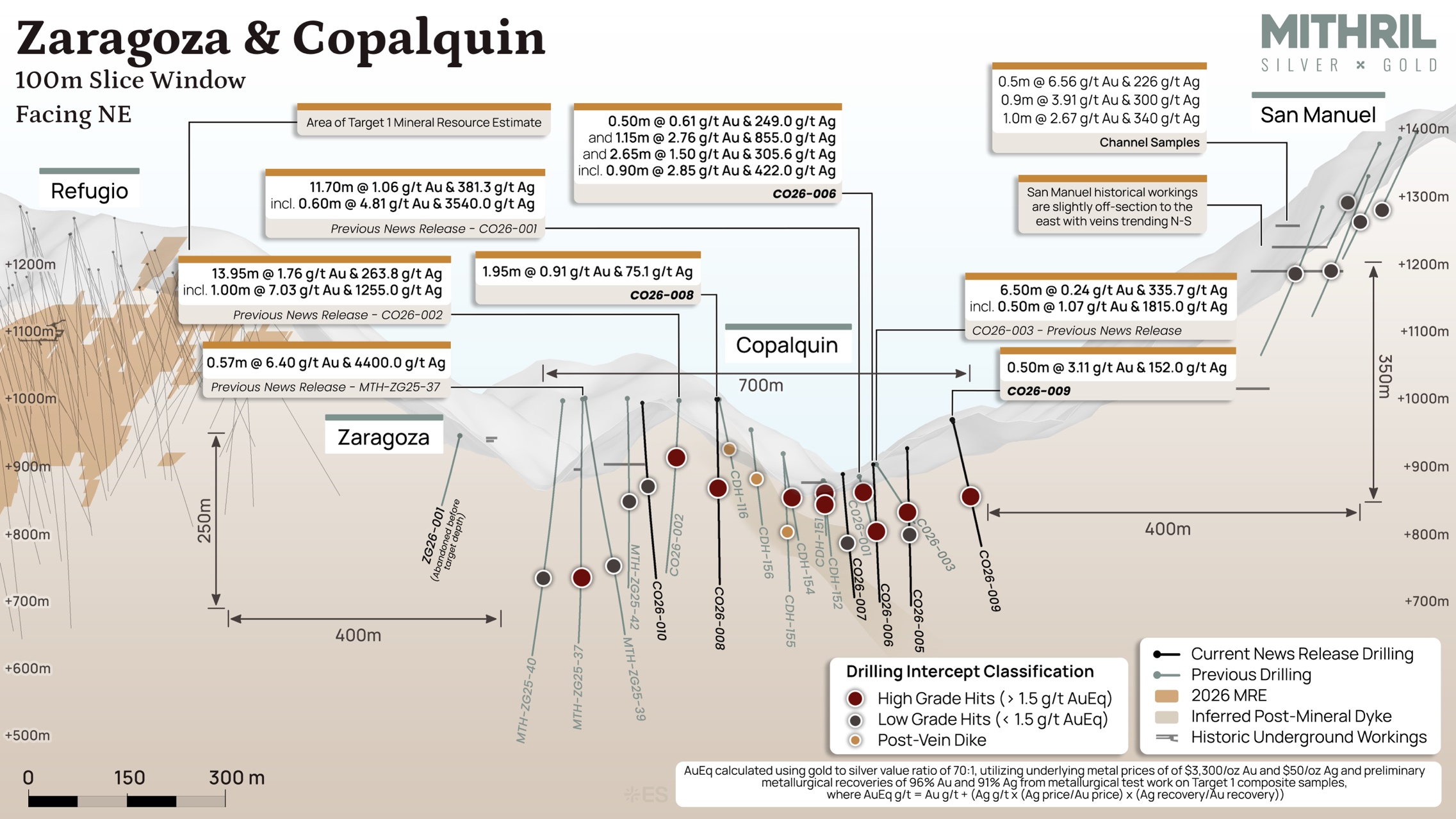
Drilling extends the reported high-grade silver and gold mineralisation in the Copalquin-Zaragoza structure to the northwest and southeast increasing defined strike from 550 m to 700 m across two sub-parallel veins. Drilling has continued to extend the tested strike with assays pending.
-
The projected vein structure remains open and untested for approximately 400 m to the northwest towards Target 1 (Refugio) and 400 m to the southeast towards the historical San Manuel mine area, providing clear step-out targets for drilling including both up and down dip.
-
Areas linking Target 4 to Target 1 and San Manuel remain open for future drill testing
“Extending high-grade mineralisation along the Copalquin-Zaragoza structure to 700 metres, with further step-out results pending, highlights the growing potential of Target 4,” said John Skeet, Managing Director and CEO. “Surface sampling at San Manuel has also identified exceptional gold-silver grades along the interpreted corridor, reinforcing the opportunity to expand the district’s mineralized footprint. We’re focused on unlocking the potential between these targets while advancing the Target 1 Scoping Study/ PEA.”
Target 4 Exploration Highlights at San Manuel
-
Geological mapping at 1:1000 scale now covers an additional 80 hectares around the San Manuel historical mine, the second largest historical producer in the Copalquin district.
-
Channel sampling at the San Manuel area confirms a higher-level gold-dominant mineralizing system, with more than 50 of 135 channel samples returning grades of 1 g/t AuEq, including individual sample results:
-
Surface sampling with up to 8.55 g/t gold and 135 g/t silver over 0.7 m and 6.18 g/t gold and 380 g/t silver over 1.2 m at San Manuel,
-
Underground sampling with up to 16.55 g/t gold and 616 g/t silver across 0.60 m within the Mina del Aire workings, and
-
Up to 10.4 g/t gold and 422 g/t silver over 0.8 m on surface at Mina Larga, and up to 11.2 g/t gold and 402 g/t silver over 0.5 m underground at the adjacent Mina Hijo.
-
The latest drilling in the Copalquin-Zaragoza area builds on the successful results of the previous three holes drilled in the area2. Vein hosted mineralisation has been extended from 550 m to 700 m strike length with new drill holes, and occurs in two sub-parallel structures, spaced approximately 10-15 m apart, named the Copalquin vein and the Copalquin FW vein. The continued success extends the strike-extent of known mineralisation along the vein and also closes the drilling gap between the Copalquin and Zaragoza workings, linking them across a series of post-mineral dykes into one semi-continuous structure. Drilling continues to systematically test the structure using lateral steps-outs of approximately 60 m and is targeting an intercept elevation of around 850 metres above sea level along the tested strike-extent in this initial program.
Click Image To View Full Size
Figure 1: Plan map showing Target 4 (Copalquin-Zaragoza) drill hole trace locations and highlight intercepts in this announcement and the Target 1 resource footprint area to the northwest (Refugio-Soledad)
Click Image To View Full Size
Figure 2: Long section view of the Copalquin-Zaragoza vein looking perpendicular to vein to the northeast
TARGET 4, COPALQUIN-ZARAGOZA DRILLING DISCUSSION
Two drills continue to work on the property with a total of 24,181 m drilled to date on the project of the budgeted 25,000 metre program for 2026 (assays pending for eight drill holes). The recent campaign has focused drilling in the Target 4 area along the Copalquin-Zaragosa structure to lay the groundwork for potential future mineral resource growth along a potential structure of 1.5 km total strike length.
Drill holes have tested the on-strike extent of the mineralized structure, with a targeted intercept elevation of approximately 850 m above sea level. Many factors influence mineralisation processes within epithermal mineral deposits, broadly including the elevation at the time of mineral formation. Drill intercepts have targeted a similar present-day elevation along strike of the vein to develop understanding of the deposit, including potential post-mineral influence in the system such as major structural block movement and re-mobilization of mineral components. This information, along with surface mapping, directs drilling activities with the objectives of extending the known mineralisation and in locating the connecting structures between the Copalquin-Zaragoza, the San Manuel and Refugio structures.
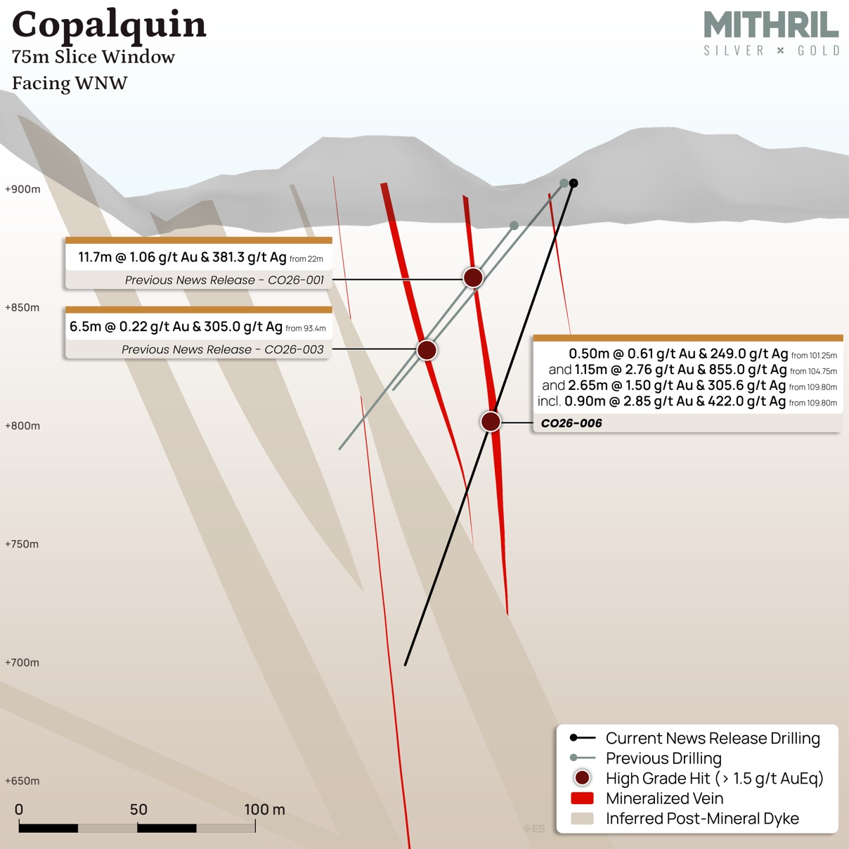
Hole CO26-006 was drilled 65 m down dip from hole CO26-003 and intersected several significant intercepts across a broad 10 m downhole interval, which corresponds with the 6.50 m @ 0.22 g/t gold, and 305 g/t silver intercepted from 93.4 m in hole CO26-0032. Hole CO26-008 targeted an 80 m gap in drilling between previously drilled hole CDH-116 (intersected post-mineral dyke) and the previous announced hole CO26-0022, and successfully intersected 1.95 m grading 0.91 g/t gold and 75.1 g/t silver from a downhole depth of 147.45 m. Hole CO26-009 tested a step-out further to the southeast from hole CO26-005 and successfully intersected a high grade banded vein over 0.50 m grading 3.11 g/t gold and 1,520 g/t silver from 154.50 m downhole depth. Table 1 lists significant drill intercepts from the recent drilling.
Hole CO26-004 was drilled as a step-out to the southeast from hole CO26-003 and was abandoned before the target depth. The hole was re-drilled as hole CO26-005, which intersected the post-mineral dyke system (Tapp) at the target vein depth. Hole CO26-007 intersected the post-mineral dyke system at approximately 70 m below CO26-001. CO26-010 intersected anomalous gold and silver values in quartz breccia structures from 184.75 m downhole. These holes refine the interpretation of the local geology and importantly the post mineral dyke, important for the geologic model and future resource work.
Table 1: Significant new drill intercepts received for Target 4 (Copalquin-Zaragoza structure)
|
Hole ID |
From (m) |
To (m) |
Length (m) |
Au g/t |
Ag g/t |
AuEq g/t3 |
AgEq g/t4 |
Cu % |
Pb % |
Zn % |
|
CO26-005 |
202.90 |
203.40 |
0.50 |
0.11 |
74.4 |
1.17 |
82 |
0.08 |
0.03 |
0.21 |
|
CO26-006 |
101.25 |
101.75 |
0.50 |
0.61 |
249.0 |
4.17 |
292 |
0.18 |
0.61 |
0.68 |
|
and |
104.75 |
105.90 |
1.15 |
2.76 |
855.0 |
14.97 |
1048 |
0.37 |
0.57 |
0.55 |
|
and |
109.80 |
112.45 |
2.65 |
1.50 |
305.6 |
5.87 |
411 |
0.69 |
0.25 |
1.20 |
|
including |
109.80 |
110.70 |
0.90 |
2.85 |
422.0 |
8.88 |
622 |
0.75 |
0.47 |
1.50 |
|
CO26-008 |
147.45 |
149.40 |
1.95 |
0.91 |
75.1 |
1.98 |
138 |
0.07 |
0.12 |
0.34 |
|
CO26-009 |
154.50 |
155.00 |
0.50 |
3.11 |
1520.0 |
24.82 |
1738 |
1.53 |
0.49 |
8.02 |
* Copper (Cu), lead (Pb) and zinc (Zn) values are shown for information only and are not included in the calculation of AuEq and AgEq nor currently being considered as part of the economic model for the deposit by Mithril.
** Length is reported as downhole length. While efforts are made to intercept veins are near perpendicular angles, additional drilling is required to estimate true widths of the veins.
Click Image To View Full Size
Figure 3: Cross section +/- 100 metres for drilling on the Copalquin Structure
TARGET 4 EXPLORATION AT SAN MANUEL
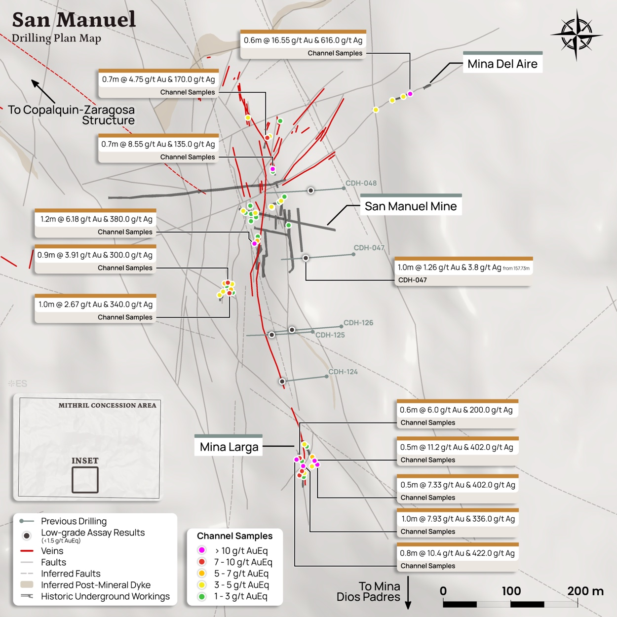
The San Manuel structure extends over 500 m from north to south and contains six main workings in three distinct prospects; San Manuel, and Apolonia, forming the main workings; Mina Larga and Mina Hijo located 300 m to the south; Dios Padre located an additional 100 m to the south, and Mina del Aire located 250 m to the northeast from the main San Manuel workings within a northeast trending structure.
San Manuel is the second largest historical underground mine in the district behind La Soledad, with the workings remaining open and accessible. The mine was developed on four levels, over 115 m of strike length between ~1,170 and 1,240 m elevations (70 m vertical). Mining was along the San Manuel and Apolonia veins, which comprise two parallel veins that lie about 30 m apart. The veins strike due north and dip steeply to inclined up to 60 degrees to the east. Veins are up to 5 m wide on the surface and up to 2.5 m wide in the accessible parts of the workings. Sampling shows up to 6.56 g/t gold and 226 g/t silver over 0.50 m.
Mina del Aire is situated along a northeast trend and is comprised of a 15 m long included adit, and a second 8 m long adit. There is no stoping from the adits. Veining observed in the adits average approximately 30 cm wide with banded and crustiform quartz. Assays from channel sample collected from with this workings graded up to 16.55 g/t gold and 616 g/t silver across 0.60 m
The Mina Larga (40 m open cut) and Mina Hijo (25 m adit) zones lie 300 m south of San Manuel / Apolonia mine on the same north-south trend. Recent channel sampling in these areas shows grades of up to 10.4 g/t gold and 422 g/t silver over 0.8 m on surface at Mina Larga, and up to 11.2 g/t gold and 402 g/t silver over 0.5 m underground at the adjacent Mina Hijo.
Dios Padre and Magdalena lie about 150 m further to the south from Mina Larga along a similar north-south trend. This area has not yet been mapped by Mithril geologists.
In May 2025, a LiDAR survey was completed of several accessible historical workings, including the stoping between Level 2 and Level 3 workings within the San Manuel mine.
Previous scout drilling at San Manuel includes two holes (482 m) in 2020, and three holes (525 m) in 2022 to test potential easterly dip of mineralisation projected from the historical workings. Mineralisation is hosted within hydrothermal quartz breccias that exhibit multi-phase cracking and sealing events, and anomalous Au and Ag were intercepted in all holes with a grade highlight of 1.00 m grading 1.26 g/t gold and 3.8 g/t silver, from 157.73 m downhole depth in hole CDH-047. Future drilling is anticipated to approach the mineralisation from a different orientation.
Table 2: Significant new channel sample intercepts grading >3g/t AuEq3 received for Target 4 (San Manuel area)
|
Location |
Length m |
Au g/t |
Ag g/t |
AuEq g/t3 |
AgEq g/t4 |
|
Underground |
|||||
|
Mina del Aire 1 |
0.60 |
16.55 |
616.0 |
25.35 |
1775 |
|
Mina Hijo |
0.50 |
11.20 |
402.0 |
16.94 |
1186 |
|
Mina Hijo |
0.50 |
7.33 |
402.0 |
13.07 |
915 |
|
San Manuel area |
0.50 |
6.56 |
226.0 |
9.79 |
685 |
|
Isabella Mine |
0.90 |
3.91 |
300.0 |
8.20 |
574 |
|
Isabella Mine |
1.00 |
2.67 |
340.0 |
7.53 |
527 |
|
Mina de los 200 |
0.70 |
4.75 |
170.0 |
7.18 |
503 |
|
Isabella Mine |
1.00 |
3.97 |
116.0 |
5.63 |
394 |
|
Mina Hijo |
0.70 |
2.76 |
179.0 |
5.32 |
372 |
|
Isabella Mine |
1.00 |
1.94 |
222.0 |
5.11 |
357 |
|
Mina del Aire 1 |
0.80 |
2.86 |
131.0 |
4.73 |
331 |
|
Mina del Aire 2 |
0.60 |
3.24 |
99.0 |
4.65 |
326 |
|
Mina del Aire 1 |
0.60 |
3.40 |
62.6 |
4.29 |
301 |
|
San Manuel Nivel 1 |
0.80 |
3.09 |
79.3 |
4.22 |
296 |
|
San Manuel Nivel 3 |
0.60 |
2.21 |
123.0 |
3.97 |
278 |
|
Mina Hijo |
0.50 |
1.82 |
123.0 |
3.57 |
250 |
|
San Manuel area |
1.10 |
2.05 |
97.0 |
3.44 |
241 |
|
San Manuel Nivel 3 |
1.00 |
2.05 |
91.7 |
3.36 |
235 |
|
Mina de los 200 |
0.80 |
1.59 |
115.0 |
3.23 |
226 |
|
Isabella Mine |
0.50 |
1.41 |
118.0 |
3.09 |
216 |
|
Surface |
|||||
|
Mina Larga |
0.80 |
10.40 |
422.0 |
16.43 |
1150 |
|
Mine Larga |
1.00 |
7.93 |
336.0 |
12.73 |
891 |
|
San Manuel area |
1.20 |
6.18 |
380.0 |
11.61 |
813 |
|
Mina Inundada |
0.70 |
8.55 |
135.0 |
10.48 |
734 |
|
Mina Larga |
0.60 |
6.00 |
200.0 |
8.86 |
620 |
|
Mina Larga |
0.60 |
4.73 |
201.0 |
7.60 |
532 |
|
San Manuel area |
0.50 |
3.18 |
188.0 |
5.87 |
411 |
|
San Manuel area |
- |
2.45 |
115.0 |
4.09 |
287 |
|
Mina Larga |
0.60 |
2.28 |
96.2 |
3.65 |
256 |
|
San Manuel area |
1.00 |
1.15 |
153.0 |
3.34 |
234 |
|
San Manuel area |
1.00 |
1.25 |
146.0 |
3.33 |
233 |
|
Mina Larga |
0.90 |
2.27 |
63.6 |
3.18 |
223 |
|
San Manuel area |
1.80 |
2.58 |
40.7 |
3.16 |
221 |
|
San Manuel area |
0.50 |
1.47 |
66.2 |
2.41 |
169 |
|
Mina Inundada |
0.80 |
0.94 |
80.5 |
2.09 |
146 |
|
Mina Larga |
0.60 |
1.15 |
30.4 |
1.58 |
111 |
|
San Manuel area |
1.20 |
0.84 |
41.9 |
1.44 |
101 |
Click Image To View Full Size
Figure 4 Plan map of the San Manuel area showing recent channel sample highlights and location of previous drilling
COPALQUIN-ZARAGOSA STRUCTURE
The historical Copalquin Mine is located on the west margin of the Copalquin Creek just above the site of the an historical 10 tpd mill and flotation plant installed in the 1970s and operated for only about 12 months due to no road access at the time. There are two tunnels driven at 290 degrees on a 0.4 to 0.8 m wide quartz vein that dips steeply to the northeast. Matrix supported hydrothermal breccia with black sulphide is observed in the vein. The vein is in the centre of a 15 m wide zone of similar thinner veins. The longer of the two tunnels is 30 m in length and has no stopes.
Across the ridge to the west in the Soledad arroyo the Zaragoza workings appear to be on the same structure. The Zaragoza workings are completely caved and inaccessible but are shown on historical maps to run at 105 degrees directly towards the Copalquin mine 300 m to the east. Both tunnels are developed in granodiorite.
In the Soledad Creek directly below the Zaragoza workings, there is a 40 m wide zone of veining surrounding a central larger vein, similar to the vein system seen at the Copalquin workings.
The Copalquin/Zaragoza Structure is open to the northwest where it trends towards the Refugio mine, and is open to the southeast towards the San Manuel mine, representing a potentially mineralised strike length of 1.5 km.
NEXT STEPS AT TARGET 4
Drilling continues along the Copalquin-Zaragoza structure using lateral step-outs of approximately 60 m, targeting the untested ~400 m extensions toward Refugio (Target 1) to the northwest and San Manuel to the southeast. In parallel, Mithril is refining its structural model to test the potential link between the silver-rich mineralisation intersected in drilling and the higher-level, gold-dominant system mapped at San Manuel. Results from ongoing drilling will be reported as assays are received.
ABOUT THE COPALQUIN AND LA DURA GOLD SILVER PROPERTIES
Mithril is undertaking an aggressive exploration program in 2026, with 25,000 metres of drilling budgeted during the year across the Copalquin District. Work in the second half of 2026 is focussing on expanding known mineralised zones, testing new high-priority targets, integrating district-wide geophysical data, and continuing to advance the Company’s district-scale exploration thesis. There are 13 target areas with 6 advancing as high-priority, including the recently upgraded resource at Target 15. The district features over 100 historical underground workings including several notable past-producing multi-level mines and some 200 small surface workings (c.1850 – 1910). Mapping and sampling across the lower half of the 70 km2 mining concession area demonstrates a large epithermal silver-gold system with multiple target areas for potential resource growth plus the conduit system responsible for the widespread silver and gold mineralisation. Of note, are the persistent and widespread high gold grades, sampled across this silver district.
Click Image To View Full Size
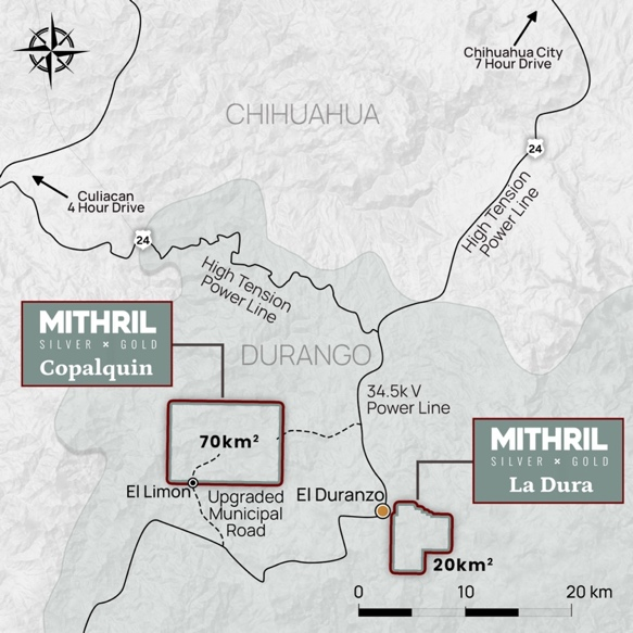
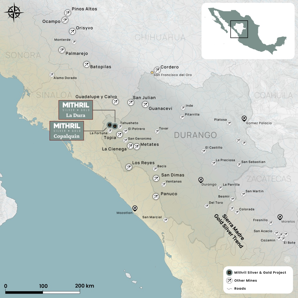
Figure 5: Mithril’s Copalquin and La Dura property locations in Durango State, Mexico
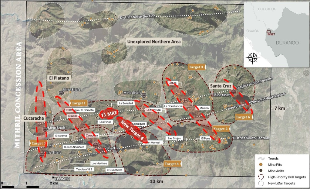
The northern half of the Copalquin concession area features large areas of alteration. The LiDAR image shows evidence of historical mining activity and indicates some key structures. Along with historical sampling data, the northern section of the property presents as a potentially significant large exploration area within Mithril’s Copalquin mining concessions.
Mithril has an exclusive option to purchase 100% interest in the Copalquin mining concessions by paying US$10M on or any time before 7 August 2028.
The nearby 20 km2 La Dura property has recently been added to the portfolio providing a brownfield property with a database of mapping, sampling and drilling6. The recent LiDAR survey7 has revealed multiple historical workings within the concession area, including the 4-level high-grade La Dura mine. An initial 1.5 km long mineralisation corridor has been identified as a future drill target. An aerial magnetic survey has been completed with interpretation work providing an additional information base to guide exploration.
Click Image To View Full Size
Figure 6: Copalquin mining concession area map (70km2) showing the current main target areas, Target 1 resource area and the Target 4 structure location with other potential areas of model application (in red) across the district.
TARGET 1 MINERAL RESOURCE AND SCOPING STUDY/PEA
The upgraded Target 1 Mineral Resource Estimate (MRE), announced on 30 June 2026 and amended on 3 July 2026, is constrained within preliminary underground mining shapes and incorporates expected mining dilution8. A total of 75% of the contained gold and silver is classified as Indicated (Table 3).
Building on the MRE, Mithril has commenced a Scoping Study/Preliminary Economic Assessment (PEA) for Target 1, targeted for early 2027, providing additional basis for the permitting work to continue progress. The supporting NI 43-101 Technical Report, "Technical Report – Updated Mineral Resource Estimate – Target 1, Copalquin Property, Durango Mexico", with an effective date of June 29, 2026, was filed on SEDAR+ on August 17, 2026 and is available at www.mithrilsilvergold.com.
Table 3: Upgraded Copalquin Target 1 Mineral Resource Estimate (underground mining shape constrained and diluted)
|
Target 1 Area |
Class |
Tonnes |
Gold |
Silver |
Gold Eq. |
Gold |
Silver |
Gold Eq. |
|
(kt) |
(g/t) |
(g/t) |
(g/t) |
(koz) |
(koz) |
(koz) |
||
|
El Refugio |
Ind |
2,557 |
3.38 |
73.7 |
4.44 |
278 |
6,061 |
365 |
|
Inf |
1,217 |
2.17 |
82.1 |
3.35 |
85 |
3,214 |
131 |
|
|
La Soledad |
Ind |
834 |
2.43 |
90.2 |
3.72 |
65 |
2,418 |
100 |
|
Inf |
219 |
2.54 |
26.1 |
2.92 |
18 |
184 |
21 |
|
|
Total |
Ind |
3,391 |
3.15 |
77.8 |
4.26 |
343 |
8,479 |
464 |
|
Inf |
1,436 |
2.23 |
73.6 |
3.28 |
103 |
3,398 |
151 |
Effective date June 29, 2026.
1. Numbers may not add due to rounding. All dollar values in United States Dollars unless otherwise noted.
2. Mineral Resources were prepared in accordance with the JORC Code (2012) and the CIM Definition Standards (2014) and Estimation of Mineral Resource and Mineral Reserve Best Practice guidelines (2019). The estimate was supervised by John Sims, President of Sims Resources LLC, independent Competent Person and Qualified Person (CPG, AIPG).
3. Mineral Resources are not Mineral Reserves and do not have demonstrated economic viability. Inferred Mineral Resources have a lower level of confidence than Indicated Mineral Resources.
4. Constrained and diluted Mineral Resources are based on metal prices of US$3,300/oz Au and US$50/oz Ag and metallurgical recoveries of 96% Au and 91% Ag. AuEq g/t = Au g/t + (Ag g/t x (Ag price/Au price) x (Ag recovery/Au recovery)).
5. Reported within mining shapes generated using Datamine's Mineable Shape Optimizer (MSO) for long hole open stoping, diluted to a minimum 2 m shape width with 92% mining recovery and a total operating cost of US$97/t processed ($60/t incremental mining, $25/t processing, $10/t G&A, $2/t sustaining).
6. Mineral Resources may be materially affected by environmental, permitting, legal, title, taxation, sociopolitical, marketing or other relevant issues. In the Company's opinion there is reasonable potential for both gold and silver to be extracted and sold.
DRILLHOLE INFORMATION BEING REPORTED IN THIS RELEASE
A summary of all holes being announced in this News Release is shown in Table 4, with a complete list of all assays >0.10 g/t AuEq listed in Table 5.
Table 4: Drill hole collar details included in this announcement
|
Hole ID |
Easting |
Northing |
Elevation |
Azimuth |
Inclination |
Depth (m) |
|
(m) |
(m) |
(m) |
(degrees) |
(degrees) |
||
|
Target 4 |
||||||
|
CO26-004* |
290385 |
2823194 |
926 |
210 |
-68 |
66 |
|
CO26-005 |
290385 |
2823194 |
926 |
210 |
-68 |
252 |
|
CO26-006 |
290320 |
2823189 |
902 |
206 |
-71 |
216 |
|
CO26-007 |
290312 |
2823256 |
888 |
212 |
-45 |
270 |
|
CO26-008 |
290106 |
2823287 |
1000 |
215 |
-65 |
306 |
|
CO26-009 |
290475 |
2823204 |
966 |
201 |
-47 |
255 |
|
CO26-010 |
290032 |
2823374 |
994 |
210 |
-55 |
325 |
Note: Some collar locations may be reported with approximate handheld GPS coordinates, while surveying with differential GPS is pending completion
* Hole CO26-004 was lost prior to target depth, re-drilled as CO26-005
Table 5: All drill results reported greater than or equal to 0.1 g/t AuEq
|
Hole ID |
From (m) |
To (m) |
Length (m) |
Au g/t |
Ag g/t |
AuEq g/t |
AgEq g/t |
|
Target 4 |
|||||||
|
CO26-005 |
136.60 |
137.10 |
0.50 |
0.02 |
5.5 |
0.10 |
7 |
|
CO26-005 |
137.60 |
138.10 |
0.50 |
0.03 |
6.6 |
0.12 |
8 |
|
CO26-005 |
202.90 |
203.40 |
0.50 |
0.11 |
74.4 |
1.17 |
82 |
|
CO26-006 |
97.10 |
97.70 |
0.60 |
0.05 |
12.9 |
0.24 |
17 |
|
CO26-006 |
101.25 |
101.75 |
0.50 |
0.61 |
249.0 |
4.17 |
292 |
|
CO26-006 |
104.05 |
104.75 |
0.70 |
0.10 |
38.2 |
0.65 |
45 |
|
CO26-006 |
104.75 |
105.90 |
1.15 |
2.76 |
855.0 |
14.97 |
1048 |
|
CO26-006 |
107.25 |
107.90 |
0.65 |
0.03 |
11.8 |
0.20 |
14 |
|
CO26-006 |
109.80 |
110.70 |
0.90 |
2.85 |
422.0 |
8.88 |
622 |
|
CO26-006 |
110.70 |
111.25 |
0.55 |
0.18 |
64.1 |
1.09 |
76 |
|
CO26-006 |
111.25 |
112.45 |
1.20 |
1.10 |
329.0 |
5.80 |
406 |
|
CO26-006 |
112.45 |
113.10 |
0.65 |
0.06 |
13.8 |
0.25 |
18 |
|
CO26-006 |
113.10 |
114.10 |
1.00 |
0.03 |
10.3 |
0.18 |
13 |
|
CO26-006 |
114.10 |
115.00 |
0.90 |
0.17 |
32.1 |
0.63 |
44 |
|
CO26-006 |
115.00 |
115.55 |
0.55 |
0.46 |
36.9 |
0.99 |
69 |
|
CO26-006 |
117.95 |
118.60 |
0.65 |
0.06 |
7.4 |
0.17 |
12 |
|
CO26-006 |
118.60 |
119.85 |
1.25 |
0.02 |
6.9 |
0.12 |
9 |
|
CO26-006 |
133.80 |
134.55 |
0.75 |
0.03 |
8.4 |
0.15 |
10 |
|
CO26-007 |
147.35 |
148.20 |
0.85 |
0.19 |
22.9 |
0.52 |
36 |
|
CO26-007 |
266.50 |
267.00 |
0.50 |
0.11 |
0.3 |
0.11 |
8 |
|
CO26-008 |
147.45 |
148.00 |
0.55 |
0.36 |
66.4 |
1.31 |
91 |
|
CO26-008 |
148.00 |
148.60 |
0.60 |
0.66 |
39.1 |
1.21 |
85 |
|
CO26-008 |
148.60 |
149.40 |
0.80 |
1.47 |
108.0 |
3.01 |
211 |
|
CO26-008 |
149.40 |
150.25 |
0.85 |
0.30 |
38.4 |
0.84 |
59 |
|
CO26-010 |
185.70 |
186.45 |
0.75 |
0.08 |
5.0 |
0.15 |
11 |
|
CO26-010 |
198.95 |
199.50 |
0.55 |
0.08 |
37.4 |
0.61 |
43 |
|
CO26-010 |
199.50 |
200.60 |
1.10 |
0.02 |
9.5 |
0.15 |
11 |
|
CO26-010 |
200.60 |
201.60 |
1.00 |
0.05 |
5.1 |
0.12 |
9 |
|
CO26-010 |
207.45 |
207.95 |
0.50 |
0.03 |
7.2 |
0.14 |
10 |
|
CO26-010 |
209.95 |
210.85 |
0.90 |
0.06 |
6.4 |
0.16 |
11 |
|
CO26-010 |
210.85 |
211.60 |
0.75 |
0.06 |
4.5 |
0.13 |
9 |
|
CO26-010 |
218.10 |
218.80 |
0.70 |
0.30 |
13.6 |
0.50 |
35 |
|
CO26-010 |
218.80 |
219.65 |
0.85 |
0.05 |
11.1 |
0.21 |
15 |
|
CO26-010 |
230.25 |
231.00 |
0.75 |
0.02 |
8.0 |
0.13 |
9 |
|
CO26-010 |
239.10 |
239.60 |
0.50 |
0.13 |
19.3 |
0.41 |
28 |
|
CO26-010 |
239.60 |
240.10 |
0.50 |
0.03 |
5.7 |
0.11 |
8 |
*See footnotes 4 and 5 for gold equivalent (AuEq) and silver equivalent (AgEq) formulas.
-ENDS-
Released with the authority of the Board.
For further information contact:
|
John Skeet |
NIKLI COMMUNICATIONS |
|
Managing Director and CEO |
Corporate Communications |
|
jskeet@mithrilsilvergold.com |
liz@mithrilsilvergold.com |
|
+61 435 766 809 |
nicole@mithrilsilvergold.com |
The Australian Securities Exchange has not reviewed and does not accept responsibility for the accuracy or adequacy of this release.
Neither TSX Venture Exchange nor its Regulation Services Provider (as that term is defined in policies of the TSX Venture Exchange) accepts responsibility for the adequacy or accuracy of this release.
COMPETENT PERSONS STATEMENT (JORC) AND QUALIFIED PERSONS (NI 43-101) STATEMENT
The information in this announcement that relates to metallurgical test results, mineral processing and project development and study work has been compiled, reviewed and approved by Mr John Skeet who is Mithril's CEO and Managing Director. Mr Skeet is a Fellow of the Australasian Institute of Mining and Metallurgy. This is a Recognised Professional Organisation (RPO) under the Joint Ore Reserves Committee (JORC) Code and Acceptable Foreign Association under NI 43-101.
Mr Skeet has sufficient experience of relevance to the styles of mineralisation and the types of deposits under consideration, and to the activities undertaken, to qualify as a Competent Person (non-independent) as defined in the 2012 Edition of the Joint Ore Reserves Committee (JORC) Australasian Code for Reporting of Exploration Results, Mineral Resources and Ore Reserves, and as a Qualified Person (non-independent) as defined by NI 43-101. Mr Skeet consents to the inclusion in this report of the matters based on information in the form and context in which it appears.
The information in this announcement that relates to sampling techniques, sample data, exploration results and geological interpretation for Mithril's Mexican project has been compiled, reviewed and approved by Mr James Barr who is Mithril's Vice President – Exploration. Mr Barr is a registered member and Professional Geologist (P.Geo.) of the Engineers and Geoscientists of British Columbia. This is a Recognised Professional Organisation (RPO) under the Joint Ore Reserves Committee (JORC) Code and recognized Canadian Professional Association under NI 43-101.
Mr Barr has sufficient experience of relevance to the styles of mineralisation and the types of deposits under consideration, and to the activities undertaken, to qualify as a Competent Person (non-independent) as defined in the 2012 Edition of the Joint Ore Reserves Committee (JORC) Australasian Code for Reporting of Exploration Results, Mineral Resources and Ore Reserves, and as a Qualified Person (non-independent) as defined by NI 43-101. Mr Barr consents to the inclusion in this report of the matters based on information in the form and context in which it appears.
The information in this announcement that relates to Mineral Resources has been compiled, reviewed and approved by Mr John Sims, a Certified Professional Geologist (CPG) with the American Institute of Professional Geologists (AIPG). This is a Recognised Professional Organisation (RPO) under the Joint Ore Reserves Committee (JORC) Code and Acceptable Foreign Association under NI 43-101.
Mr Sims is acting as the Competent Person (independent), as defined in the 2012 Edition of the Joint Ore Reserves Committee (JORC) Australasian Code for Reporting of Exploration Results, Mineral Resources and Ore Reserves, and as the Qualified Person (independent) as defined by NI 43-101, for the reporting of the Upgraded Copalquin Target 1 Mineral Resource Estimate, with effective date of June 29, 2026. A site visit was carried out by Mr Sims between 5 May 2025 and 7 May 2025 to observe the drilling, logging, sampling and assay database. Mr Sims consents to the inclusion in this report of the matters based on information in the form and context in which it appears.
The relevant sections of "JORC Code, 2012 Edition – Table 1" are incorporated into the Public Reports announced on ASX dated 3 July 2026 – Amended Announcement Copalquin Project Target 1 Deposit MRE, and 27 August 2026 – Wide, High-Grade Hits Confirm 550m Strike at Target 4. The NI 43-101 Technical Report entitled "Technical Report – Updated Mineral Resource Estimate – Target 1, Copalquin Property, Durango Mexico" was filed on SEDAR+ on August 17, 2026.
Previously Reported Information
This report includes information that relates to Exploration Results and Mineral Resources extracted from the ASX announcements referenced in this report, which are available to view on www.asx.com.au and www.mithrilsilvergold.com. The Company confirms that it is not aware of any new information or data that materially affects the information included in the original market announcements and, in the case of estimates of Mineral Resources, that all material assumptions and technical parameters underpinning the estimates in the relevant market announcement continue to apply and have not materially changed. The Company confirms that the form and context in which the Competent Persons' findings are presented have not been materially modified from the original market announcements.
Qualified Persons – NI 43-101
Scientific and technical information in this report has been reviewed and approved by Mr John Skeet (FAusIMM, CP), Mithril's Managing Director and Chief Executive Officer. Mr Skeet is a qualified person within the meaning of NI 43-101. Samples are sent to ALS Global with sample preparation performed in Chihuahua City, Mexico and assaying of sample pulps performed in North Vancouver, BC, Canada.
JORC Code, 2012 Edition – Table 1
Section 1 Sampling Techniques and Data
|
Criteria |
JORC Code explanation |
Commentary |
|
Sampling techniques |
|
|
|
Drilling techniques |
|
|
|
Drill sample recovery |
|
|
|
Logging |
|
|
|
Sub-sampling techniques and sample preparation |
|
|
|
Quality of assay data and laboratory tests |
|
|
|
Verification of sampling and assaying |
|
|
|
Location of data points |
|
|
|
Data spacing and distribution |
|
|
|
Orientation of data in relation to geological structure |
|
|
|
Sample security |
|
|
|
Audits or reviews |
|
|
Section 2 Reporting of Exploration Results
|
Criteria |
JORC Code explanation |
Commentary |
||||||||||||||||||||||||||||||||||||||||||||||||||||||||||||||||||||||||||||||||||||||||||||||||||||||||||||||
|
Mineral tenement and land tenure status |
|
|
||||||||||||||||||||||||||||||||||||||||||||||||||||||||||||||||||||||||||||||||||||||||||||||||||||||||||||||
|
Exploration done by other parties |
|
|
||||||||||||||||||||||||||||||||||||||||||||||||||||||||||||||||||||||||||||||||||||||||||||||||||||||||||||||
|
Geology |
|
|
||||||||||||||||||||||||||||||||||||||||||||||||||||||||||||||||||||||||||||||||||||||||||||||||||||||||||||||
|
Drill hole Information |
|
|
||||||||||||||||||||||||||||||||||||||||||||||||||||||||||||||||||||||||||||||||||||||||||||||||||||||||||||||
|
Data aggregation methods |
|
|
||||||||||||||||||||||||||||||||||||||||||||||||||||||||||||||||||||||||||||||||||||||||||||||||||||||||||||||
|
Relationship between mineralisation widths and intercept lengths |
|
|
||||||||||||||||||||||||||||||||||||||||||||||||||||||||||||||||||||||||||||||||||||||||||||||||||||||||||||||
|
Diagrams |
|
|
||||||||||||||||||||||||||||||||||||||||||||||||||||||||||||||||||||||||||||||||||||||||||||||||||||||||||||||
|
Balanced reporting |
|
|
||||||||||||||||||||||||||||||||||||||||||||||||||||||||||||||||||||||||||||||||||||||||||||||||||||||||||||||
|
Other substantive exploration data |
|
|
||||||||||||||||||||||||||||||||||||||||||||||||||||||||||||||||||||||||||||||||||||||||||||||||||||||||||||||
|
Further work |
|
|
1 AgEq calculated using metal prices of USD $3,300/oz Au and $50/oz Ag where AgEq g/t = Ag g/t + (Au g/t x (Au price/Ag price) x (Au recovery/Ag recovery)) with metallurgical recoveries of 96% Au and 91% Ag.
2 see News Release “Mithril drills wide, high-grade intercepts confirming 550 m strike with first systematic drilling in the Copalquin-Zaragoza structure at Target 4” dated August 27, 2026
3 AuEq calculated using metal prices of USD $3,300/oz Au and $50/oz Ag where AuEq g/t = Au g/t + (Ag g/t x (Ag price/Au price) x (Ag recovery/Au recovery)) with metallurgical recoveries of 96% Au and 91% Ag.
4 AgEq calculated using metal prices of USD $3,300/oz Au and $50/oz Ag where AgEq g/t = Ag g/t + (Au g/t x (Au price/Ag price) x (Au recovery/Ag recovery)) with metallurgical recoveries of 96% Au and 91% Ag.
5 See Copalquin – ‘TARGET 1 MINERAL RESOURCE AND SCOPING STUDY/PEA’ section at the end of this announcement
6 See Announcement 5 December 2025, MITHRIL TO ACQUIRE THE LA DURA GOLD-SILVER PROPERTY
7 See Announcement 25 February 2026, MITHRIL LIDAR STUDY REVEALS 1.5 KM TREND & HISTORIC MINES
8 See ASX announcements dated 30 June 2026, "Mithril Derisks Target 1 with 75% Indicated Resource", and 3 July 2026, "Amended Announcement Copalquin Project Target 1 Deposit MRE".
Copyright (c) 2026 TheNewswire - All rights reserved.